ArcGIS Enterprise is a Web GIS software product comprising four software components. The backbone of geospatial content in ArcGIS Enterprise is your GIS web services powered by ArcGIS Server, and the primary location for users to access, visualize, and work with geospatial content is the ArcGIS Enterprise portal. The portal helps transform your ArcGIS Server services into information products and helps you securely share content with your users and stakeholders.
Though it can be deployed as stand-alone software, integrating ArcGIS Server with the ArcGIS Enterprise portal enables efficient, powerful workflows for your organization. There are three ways in which ArcGIS Server can be used by the ArcGIS Enterprise portal:
- You can federate one or more ArcGIS Server sites with the portal to integrate its security and sharing models.
- You can assign a federated ArcGIS Server site to act as the portal's hosting server, allowing users to publish data and maps to a wider audience as web services.
- You can register individual services from any ArcGIS Server site with the portal, whether or not it is federated (or even if it is your own server).
This topic, and this section of the documentation, covers the three approaches to ArcGIS Enterprise integration.
Functions available through integration
The table below provides a summary of common ArcGIS Enterprise portal features available with and without ArcGIS Server integration. You can combine these approaches to meet the level of integration necessary for your organization. For example, your portal might expose items from a federated server with items individually registered from other servers.
| Feature | No server integration | With federated server only | With hosting server | Notes |
|---|---|---|---|---|
Add items to the portal (for example, files, web apps, and services) |
|
|
| All portal items are treated the same in security and sharing. |
Add shapefiles and .csv files with addresses to a web map |
| A hosting server is required, as it performs validation of shapefile and address data added to the web map. | ||
Create web maps |
|
|
| You are not required to federate or configure a hosting server to create web maps. |
Geocode individual addresses in a web map |
|
|
| You are not required to federate or configure a hosting server to geocode individual addresses in a web map. |
Batch geocode addresses in a web map (for example, from a .csv file) |
| A hosting server is required, as it performs validation of the address data added to the web map. The geocode service used to locate addresses can be from ArcGIS Server or an ArcGIS Online organization. | ||
Publish hosted services (for example, hosted tile, feature, and scene layers) |
| A hosting server is required, as it performs data validation, stores service data, and hosts services. You can publish hosted services using ArcGIS Pro or directly in the portal when adding an item to the website. Publishing hosted scene layers also requires that the hosting server be configured with a tile cache data store. | ||
Share layers and maps from ArcGIS for Office |
| A hosting server is required to allow portal users to share layers and maps from ArcGIS for Office. | ||
Publish layers from ArcGIS Pro that reference data from registered sources (for example, publish map image layers that contain data from a registered database) |
| The data source must be registered with the ArcGIS Server site prior to publishing. You can publish these layers using ArcGIS Pro 1.2 or later. | ||
Use spatial analysis tools in Map Viewer Classic or ArcGIS Insights |
| Spatial analysis tools are hosted as a series of tasks on the server. The tools create hosted feature layers as output. These hosted feature layers are feature services that run on the hosting server. To use these tools, the hosting server must be configured with a relational data store. | ||
Perform big data analytics in Map Viewer Classic or ArcGIS Insights |
| Big data analytics tools also create feature layers as output, which require a hosting server to run the underlying services. To use these tools, the hosting server must be configured with a spatiotemporal big data store. |
Register services
You can register ArcGIS Server services as items in the portal, allowing portal users to easily find them and add them to web maps. The services can come from any ArcGIS Server site you can access through the service URL. Registering services is the most loosely coupled way in which a server can be integrated with a portal.
If your portal requires encrypted communication through HTTPS, the services you register must use HTTPS if they are from outside your domain.
When you register a service as a portal item, the life spans of the service and the item are not connected. In other words, if the underlying service goes away, you are responsible for deleting the item from your portal.
Federate a server
Federating an ArcGIS Server site integrates the security and sharing models of your portal with one or more ArcGIS Server sites. When an ArcGIS Server site is federated with an ArcGIS Enterprise portal, users can create hosted layers and perform spatial analysis on content in the portal's Map Viewer Classic, and security and access are controlled at the web tier. Federating ArcGIS Server sites designated with a particular role, such as ArcGIS Image Server or ArcGIS GeoEvent Server, gives portal members access to their analysis functions.
Note:
The elements of your ArcGIS Enterprise base deployment, including the hosting server, must all be at the same version as your portal. Instances of ArcGIS GeoEvent Server and ArcGIS GeoAnalytics Server, and ArcGIS Image Server raster analytics sites must also match the portal's version.
However, some ArcGIS Server sites at version 10.5 or later can be federated with a portal of a more recent version. This applies to additional ArcGIS GIS Server sites beyond the hosting server, and to any ArcGIS Image Server not designated for raster analytics. No ArcGIS Server site can be federated with a portal from an earlier version than its own.
All content in the portal is treated as an item, whether it is an ArcGIS Server service, a web map or app, a shapefile, or any other supported file type, and content security is determined at the item level.
Learn about the ArcGIS Enterprise security model
When you federate a server, access and authorization to server resources are controlled by the portal. This means the following occur:
- You access ArcGIS Server using portal members—ArcGIS Server users and roles are replaced by those of the portal. Portal credentials, whether they be through the portal's built-in identity store or an external identity provider, are used to sign in to ArcGIS Server Manager. By consolidating portal and server users, you clarify the administration of GIS resources and ensure a convenient sign-in experience when accessing secured ArcGIS Server resources. (Note that your custom ArcGIS Server roles will not be transferred to the portal when you federate.)
- Access to ArcGIS Server services is controlled by the portal's sharing model—Every ArcGIS Server service you publish to your federated server is automatically shared as an item in the portal. The sharing model of the portal allows you to keep the service private to its publisher or shared with one or more groups of portal users. Alternatively, you can share the item with your whole organization (any signed-in user) or enable anonymous access so that anyone can view it. This sharing model gives you an extra level of granularity when defining access to your ArcGIS Server services.
Note:
Although federating provides a convenient sign-in experience and allows you to take advantage of the portal's sharing model, this impacts how you and your existing users access and administer the federated server. Before federating, review the information in Administer a federated server to learn more about how federating will impact your existing site.
Once an ArcGIS Server site is federated with the portal, services published to the federated server are automatically shared with the portal. Also, portal users are used to access both the portal and the federated server.
You can have multiple ArcGIS Server sites federated with one portal. For example, you might have GIS Server, ArcGIS Image Server, and ArcGIS GeoEvent Server sites federated with your portal. All federated ArcGIS Server sites are accessed using portal accounts, not ArcGIS Server accounts.
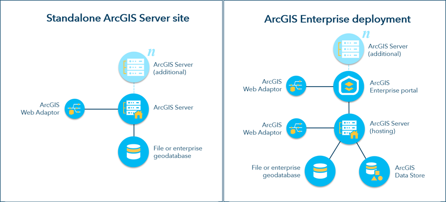
The following diagram shows the difference between a conceptual stand-alone ArcGIS Server site and a base ArcGIS Enterprise deployment.

For more information, see Federate an ArcGIS Server site with your portal.
Designate a hosting server
A federated server running ArcGIS GIS Server can be further integrated with your portal if you designate it as a hosting server. A portal can have one hosting server. A hosting server allows portal users to do the following:
- Publish cached maps, feature services, WFS services, and scene services (hosted tile layers, feature layers, WFS layers, and scene layers) to the portal from other clients or within the portal website.
- Share layers and maps from ArcGIS for Office.
- Create maps by adding .csv files and shapefiles from local machines to Map Viewer Classic.
- Batch geocode addresses from a .csv file.
- Perform analysis or big data analytics in Map Viewer Classic or ArcGIS Insights.
License:
A GIS Server site must be licensed as Standard or Advanced, not Basic, to be designated a hosting server.
A hosting server is the highest level of integration that can be achieved between a portal and a GIS Server site.
When exposing a hosting server, closely monitor server resources and usage to ensure the server can bear the load from the portal users. If you anticipate many users hosting large numbers of services, you may want to add machines to your site before you configure the hosting server.
To designate a server as a hosting server, configure the server with a relational data store and a tile cache data store created through ArcGIS Data Store. When users publish hosted feature layers to your portal, the data is copied to the relational data store. When you delete a hosted feature layer item from the portal, the underlying feature service is deleted from the hosting server, and the data is deleted from the relational data store.
Legacy:
At ArcGIS Enterprise 11.3, the use of an enterprise geodatabase as the hosting server's managed database is no longer supported, though legacy installations may still be functional. If you are configuring a new hosting server, configure a relational data store using ArcGIS Data Store.
The relational data store is also required to allow portal users to add .csv files and shapefiles to the map, or share layers and maps from ArcGIS for Office.
If your portal will include federated ArcGIS GeoEvent Server servers or ArcGIS GeoAnalytics Server servers, your hosting server must also be configured with a spatiotemporal big data store created through ArcGIS Data Store.
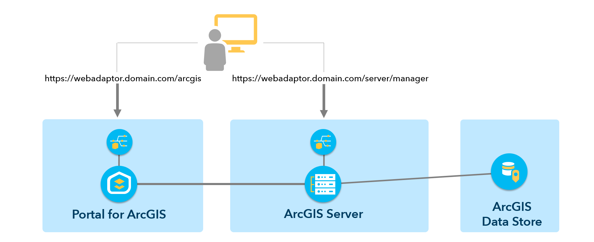
The following diagram shows an ArcGIS Server site federated to an ArcGIS Enterprise portal, with the URL patterns used to access both components via their web adaptors. A relational type data store using ArcGIS Data Store is shown registered with the server.

See Configure a hosting server for your portal to learn how to set up a hosting server.
